.png)
Communities were selected on the basis of several criteria, including a willingness to participate, demographic diversity, diversity in municipality type, density, size, varying stages in comprehensive planning, and physical vulnerability to coastal flooding.
'18-'19 Communities
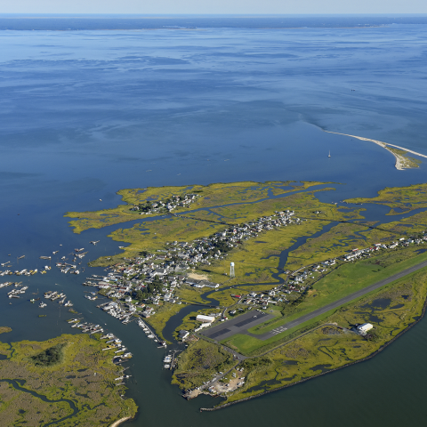
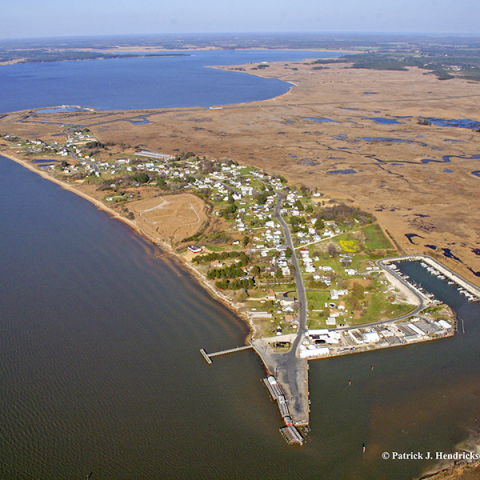
Tangier
The Town of Tangier is situated on an island in the Chesapeake Bay. Due to sea level rise and the island’s subsidence, the island has lost 67% of its landmass since the 1850s. Today, Tangier is 3.2 square miles in area with the highest point of elevation only six feet above mean sea level.
According to the 2016 American Communities Survey 5-Year Estimates, Tangier has a population of 501. The median age in the county is 53.6, which is 15.9 years higher than the national median age.
According to the Eastern Shore of Virginia Hazard Mitigation Plan 2016, the whole town is within the wind-borne debris hazard area. The island also faces an acute coastal erosion problem. By destroying trees, dunes and other natural defenses, coastal erosion exacerbates the island’s vulnerability to high winds and flooding.
Scorecard:
Maps:
Tangier Opportunities for Mitigating Flooding Map
Tangier Potential Inundation Map
Photo courtesy of Patrick J. Hendrickson/Highcamera.com

Wachapreague
The town of Wachapreague rests on an inlet of Bradford Bay on the southeast coast of Accomack County. Popularly known as the Little City by the Sea, the town of Wachapreague has a total area of 0.3 square miles and is located in the southernmost portion of the Delmarva Peninsula in Accomack County, Virginia. The Wachapreague Channel winds from the town, through the seaside marsh, and out to the barrier islands. The town’s economy is mainly derived from the businesses centered on the waterfront.
According to the 2016 American Communities Survey 5-Year Estimates, Wachapreague has a population of 194. The median age in the county is 59.8, which is 22.1 years higher than the national median age.
As per the Eastern Shore of Virginia Hazard Mitigation Plan 2016, Wachapreague is primarily vulnerable to flooding from northeasters and hurricanes. The Eastern Shore Hazard Identification and Risk Assessment, for example, identified numerous areas where flooding occurs due to improper drainage. There is a shortage of shelter space during natural hazard events due to a lack of manpower and the availability of safe structures.
The town received Hazard Mitigation Grant Program funding to elevate homes in response to damage from Hurricane Isabel in 2003. The town continues to work on addressing street flooding and preparing for chronic inundation by recommending the elevation of all new construction. Several Wachapreague residents are proactively working to protect themselves from flood damage by purchasing flood insurance even in places where it is not mandatory, yet financial barriers continue to be a challenge.
Scorecard and Resilience Action Checklist:
Wachapreague's Resilience Action Checklist
Maps:
Wachapreague Critical Infrastructure Maps- 2040 and 2065 Conditions
Wachapreague Opportunities for Mitigating Flooding Map
Wachapreague Potential Inundation Map
Other Resources:
Wachapreague Emergency Information Magnet
Photo courtesy of the Town of Wachapreague
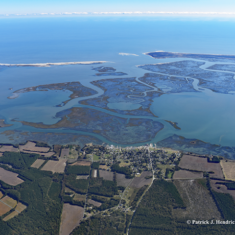
Northampton County
Northampton County is located on the southern portion of the Eastern Shore of Virginia. Like Accomack, Northampton displays a predominantly pastoral landscape dotted with farms and sparsely populated communities. Northampton County is comprised of 212 square miles of land and 584 square miles of water. Much of the county's land is devoted to environmental preservation and wildlife protection. The county is the site of the Eastern Shore of Virginia National Wildlife Refuge and Kiptopeke State Park.
According to the 2016 American Communities Survey 5-Year Estimates, Northampton County has a population of 12,118. Residents of Northampton County are distributed among six incorporated towns. The median age in the county is 48.4, which is 10.7 years higher than the national median age.
According to the Eastern Shore of Virginia Hazard Mitigation Plan 2016, Northampton County is primarily vulnerable to flooding from sea level rise and from major storm events. A FEMA Flood Risk Report estimates that 212.2 square miles of the county’s land area is within the Special Flood Hazard Area.
Like Accomack County, Northampton County signed on to and actively participated in the creation of the Eastern Shore of Virginia Hazard Mitigation Plan in 2016. The plan enumerates numerous objectives such as elevating homes in village of Oyster and identifying critical coastal erosion places like Tankards Beach, located on Savage Neck under the 2001 Northampton County Comprehensive Plan that the county has agreed to complete to ensure that it has sufficient strategies in place for dealing with its vulnerabilities.
Scorecard and Resilience Action Checklist:
Northampton County's Scorecard
Northampton County's Resilience Action Checklist
Maps:
Northampton County Basic Risk Maps- 2040 and 2065 Conditions
Northampton County Key Asset Maps- 2040 and 2065 Conditions
Northampton County Critical Infrastructure Maps- 2040 and 2065 Conditions
Northampton County Complex Risk Maps- 2040 and 2065 Conditions
Northampton County Opportunities for Mitigating Flooding Map
Northampton County Potential Inundation Map
Battle Point Critical Infrastructure Maps- 2030 and 2040 Conditions
Cape Charles Critical Infrastructure Maps- 2030, 2040, and 2065 Conditions
Oyster Critical Infrastructure Maps- 2030 and 2040 Conditions
Red Bank Critical Infrastructure Maps- 2030 and 2040 Conditions
Smith Beach Critical Infrastructure Maps- 2030 and 2040 Conditions
Willis Wharf Critical Infrastructure Maps- 2030 and 2040 Conditions
Other Resources:
Flooding and Sea Level Rise on the Eastern Shore: Frequently Asked Questions
Presentation to Northampton County Planning Commission
Northampton County Emergency Information Magnet
Photo courtesy of Patrick J. Hendrickson/Highcamera.com
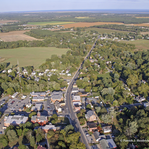
Onancock
The Town of Onancock lies on an inlet on the western shore of Accomack County. Captain John Smith called this place “the Gem of the Eastern Shore” when he first visited the site in the 1600s. Today, Onancock encompasses an area of one square mile and is one of the largest towns on Virginia’s Eastern Shore. There are many antique and lovely waterfront houses along Onancock Creek, which has branches surrounding the town to both the north and south.
According to the 2016 American Communities Survey 5-Year Estimates, the Town has a population of 1,234. The median age in the county is 48.9, which is 11.2 years higher than the national median age.
Onancock is primarily vulnerable to coastal flooding from large storms, such as hurricanes and northeasters, according to the Eastern Shore of Virginia Hazard Mitigation Plan 2016. Due to its relatively porous soil, higher elevation, and distance from the Chesapeake Bay shoreline, however, Onancock has lower vulnerability to chronic flooding than many other Eastern Shore localities, with the exception of recurrent flood zones, such as the wharf and the town’s wastewater treatment plant.
The Town Plan identifies the 100-year floodplain but does not identify any other hazards. The plan also sets objectives related to the preservation of open space, improvement of Onancock harbor, improvement of the wastewater treatment facility, upgrade of the water lines to meet State mandates and fire protection, and the continued enforcement of the Resource Protection Areas within the Town to assist with managing storm water runoff.
How The RAFT Contributed to One Community’s Resilience
RAFT implementation member, Joy Marino of Onancock, Virginia, shares her community's experience with The RAFT process and offers advice for other communities developing their own Resilience Action Checklists. See this link to the full video.
Scorecard and Resilience Action Checklist:
Onancock's Resilience Action Checklist
Maps:
Onancock Critical Infrastructure Maps- 2040 and 2065 Conditions
Onancock Opportunities for Mitigating Flooding Map
Onancock Potential Inundation Map
Onancock Sea Level Rise 1, 3 and 5 ft Parcel Map
Onancock Sea Level Rise 1, 3 and 5 ft Satellite Map
Other Resources:
Onancock Emergency Information Magnet
Photo courtesy of Patrick J. Hendrickson/Highcamera.com
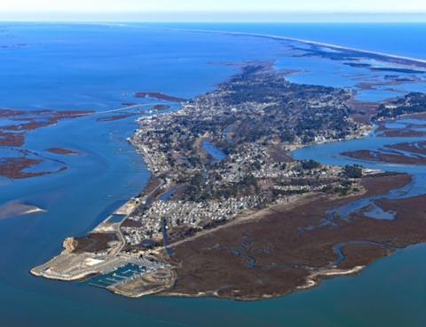
Chincoteague
The Town of Chincoteague rests on an island off the northeast coast of Accomack County. Chincoteague is located on an ancient barrier island formed around 4,000 years ago parallel to Virginia’s Eastern Shore and is surrounded by Chincoteague Bay and Assateague Island. Given its location, Chincoteague protects significant parts of Accomack County from seaside coastal erosion. Of Chincoteague’s total area of 37.3 square miles, only 9.1 square miles is land with the remaining 28.2 square miles tidal marsh and waters.
According to the 2016 American Communities Survey 5-Year Estimates, Chincoteague has a population of 2,919. The median age in the county is 53.5, which is 15.8 years higher than the national median age.
According to the Eastern Shore of Virginia Hazard Mitigation Plan 2016, Chincoteague is primarily vulnerable to coastal flooding from large storms, such as hurricanes and northeasters. A FEMA Flood Risk Report indicates that almost the entire town is in the 100-year floodplain. In fact, a large part of Chincoteague Island in the north is uninhabited but serves an important role in draining storm water.
Chincoteague has begun to create a storm water Master Plan to mitigate storm water flooding vulnerability. The town implemented Phase 1 of the plan in 2011 and is currently working on Phase 2.
Scorecard and Resilience Action Checklist:
Chincoteague's Resilience Action Checklist
Maps:
Chincoteague Critical Infrastructure Maps- 2030, 2040, and 2065 Conditions
Chincoteague Opportunities for Mitigating Flooding Map
Chincoteague Potential Inundation Map
Chincoteague Sea Level Rise 1-3 ft Parcel Map
Chincoteague Sea Level Rise 1-3 ft Satellite Map
Other Resources:
Beach Relocation Economics Report
Chincoteague Emergency Information Magnet
Photo courtesy of Patrick J. Hendrickson/Highcamera.com
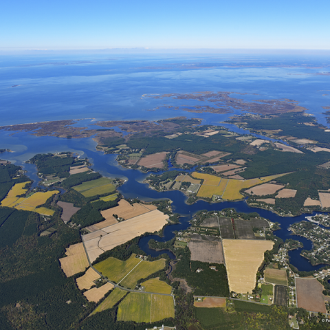
Accomack County
Accomack County is situated on the northern portion of the Eastern Shore of Virginia. The sparse settlement patterns of the Eastern Shore communities have left the county with predominantly undisturbed ecosystems. The 476 square miles of Accomack County land exhibits a bucolic landscape of expansive farmland flecked with farmsteads and small towns. The 855 square miles of water contained within county limits includes the coastal waters of the Chesapeake Bay and the Atlantic Ocean, along with extensive wetlands.
According to the 2016 American Communities Survey 5-Year Estimates, Accomack County has a population of 33,060. Among the county's fourteen incorporated towns are the RAFT-participating communities of Chincoteague, Onancock, Saxis, Tangier and Wachapreague. The median age in the county is 45.4, which is 7.7 years higher than the national median age. Census data indicates an increase in the number of non-English speaking residents, namely of Creole and Spanish speakers.
According to the Eastern Shore of Virginia Hazard Mitigation Plan 2016, Accomack County is vulnerable to several environmental hazards. The county is subject to a considerable risk from high wind speeds during storm events, particularly during the hurricane season. The county is experiencing coastal erosion along both the bayside and seaside coasts, although the seaside erosion is mitigated by the presence of barrier islands, such as Chincoteague Island. A 2015 FEMA Flood Risk Report estimates that over two-thirds of the county’s land area is within the Special Flood Hazard Area. The county is also at risk from flooding from storm events.
In an effort to address its vulnerabilities, and increase resilience, Accomack County has signed on to and actively participated in the creation of the Eastern Shore of Virginia Hazard Mitigation Plan 2016. The plan enumerates numerous objectives that the county has agreed to complete to ensure that it has sufficient strategies in place for dealing with its vulnerabilities.
Scorecard and Resilience Action Checklist:
Accomack County's Resilience Action Checklist
Maps:
Accomack County Critical Infrastructure Maps- 2040 and 2065 Conditions
Accomack County Opportunities for Mitigating Flooding Map
Accomack County Potential Inundation Map
Other Resources:
Accomack County's Emergency Information Magnet
Accomack County's Know Your Zone vs. Flood Zone Card
Beach Relocation Economics, Accomack County, VA
Flooding and Sea Level Rise on the Eastern Shore: Frequently Asked Questions
Incorporating Resilience: Comprehensive Plan Comparison Chart
Living Shorelines: Barriers and Promotions for Accomack County, VA
Photo courtesy of Patrick J. Hendrickson/Highcamera.com
Saxis
The Town of Saxis is located in northwestern Accomack County on the shore of the Pocomoke Sound. The town abuts the Saxis Wildlife Management Area, a conserved marshland where residents and visitors alike engage in outdoor recreational activities like hunting, bird watching, and wildlife viewing.
According to the 2016 American Communities Survey 5-Year Estimates, Saxis has a population of 213. The median age in the town is 57.2, which is 19.5 years higher than the national median age.
According to the Eastern Shore of Virginia Hazard Mitigation Plan 2016, Saxis is primarily vulnerable to coastal erosion, coastal flooding, and high winds. All of Saxis is within the wind-borne debris hazard area. The town faces serious coastal erosion problems, which heighten its vulnerability to coastal flooding, as more and more roads become inaccessible during both tidal and stormwater flood events.
In response to flooding from hurricanes, the town has elevated over a dozen houses. The U.S. Geological Survey, in cooperation with Accomack County and the Town of Saxis has also installed a new tide gauge station at the Saxis Marina to help emergency planners protect the shorelines of the Eastern Shore.
Scorecard and Resilience Action Checklist:
Saxis' Resilience Action Checklist
Maps:
Saxis Critical Infrastructure Maps- 2040 and 2065 Conditions
Saxis Opportunities for Mitigating Flooding Map
Saxis Potential Inundation Map
Other Resources:
Saxis Emergency Information Magnet
Photo courtesy of Patrick J. Hendrickson/Highcamera.com